
Elysium Planitia Archaeological Analysis (Part One)
Possible Evidence of Large Settlement Patterns on Mars

I HIGHLY recommend first reading the Archaeological Primer essay to provide foundational information about what I’m about to present.

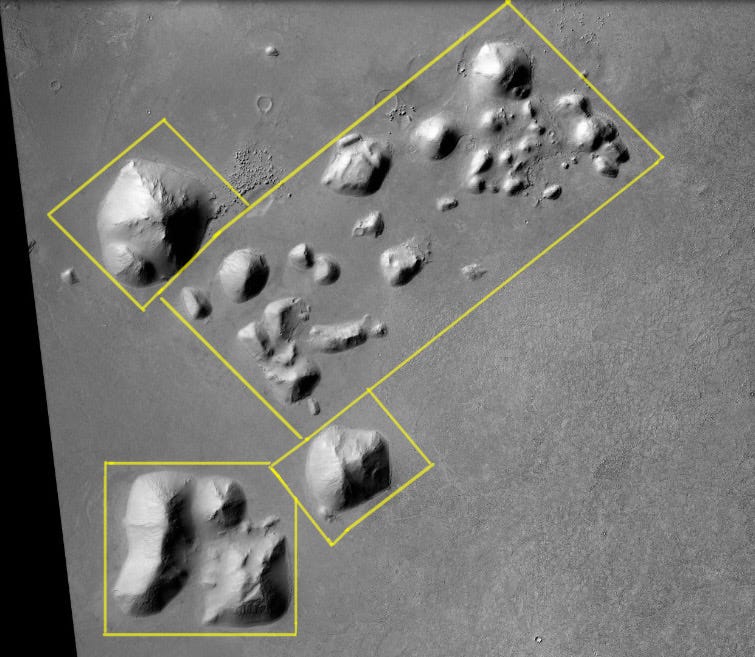
For my money, this single photo might be the most compelling evidence for artificial structures on Mars. I’ve spent at minimum 72 hours analyzing it. Every time I come back to it, I find a new detail to explore — and this photo only scrapes the surface of the anomalies within the greater Elysium Planitia region.
Context is the most important factor in archaeology, similar to the cruciality of keeping a crime scene clean. The geological layer a small artifact is found in will help confirm its age and thus what historical group could be responsible for it, but only if that information is recorded before the artifact is moved. A shelter thought to be isolated will have its entire narrative changed after archaeological survey expands to the surrounding area and discovers it’s part of a village.
Other Martian researchers tend to focus on singular anomalous features. My analysis will be a little different. Using my formal education in history and archaeology, I’ll be doing detailed contextual analysis of the entire area to establish the case for a settlement pattern. Large artificial structures are rarely built in isolation; they are usually part of a city, which is then surrounded by small towns, villages, infrastructure (farms, canals etc.), and artistic/nonfunctional features (statues etc.). If these large structures are artificial, we should be able to find signs of the large population necessary to build such a structure.
This essay will focus on the large features in the photo. In Part Two, I will focus on the geography and environment of the area, including erosion patterns of the structures. There is no editing or enhancement on the photos in this essay beyond marking anomalies, and one close-up photo with brightness/contrast edited in Lightroom (noted in its caption). I do not use any AI or upscaling software.
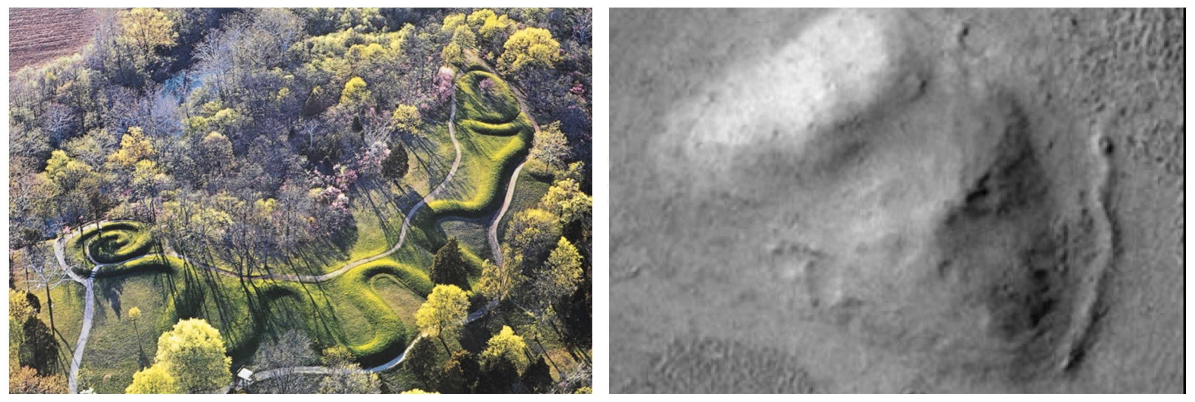
I want to make clear that I am in no way insinuating any connection between these ruins and Earth cultures. I will only use photos from Earth to make visual comparisons of structural features. Many in Ufology are far too quick to draw a straight line between two groups just because they both built a pyramid. Research would clarify that pyramidal structures are the most stable architectural shape for massive, monumental architecture without the use of steel. That’s why so many cultures have them, and why modern humans don’t build pyramids anymore. We have steel now. We can build much, much more impressive structures. Pyramids are a reflection of a society’s technological level, not its culture.
I also don’t subscribe to the theory that any group on Mars would have built something meant to be seen by us from the air or left “messages” behind for us to find. It’s irrational from many different angles. I can’t tell you anything about who might have built these things. I’m only here to point out they exist.
My humble request is to set aside your pre-conceived notions about what is possible regarding life on Mars, and examine what is in these photos with a clean slate. Forget the idea of a dead planet— an idea that is rapidly dissolving in the face of science. If it’s helpful, imagine these features are on Earth: would you be confident they were natural when you know humans exist to build them?
Elysium Planitia
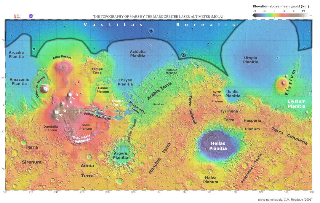
Elysium Planitia is a broad plain near the equator of Mars with the most recorded seismic activity, the most recent signs of volcanic activity, and signs of multiple water floods in the past. NASA has mapped ash-covered water ice in the area, similar in size to the North Sea, likely the remains of said flood waters. The area of the photo is part of a smaller region within Elysium called Cerberus Palus— “Palus” meaning “swamp”— which at one point contained a lake fed by the Athabasca Valles outflow channel system. Recall that all major First Civilizations on Earth began in similar river valleys.
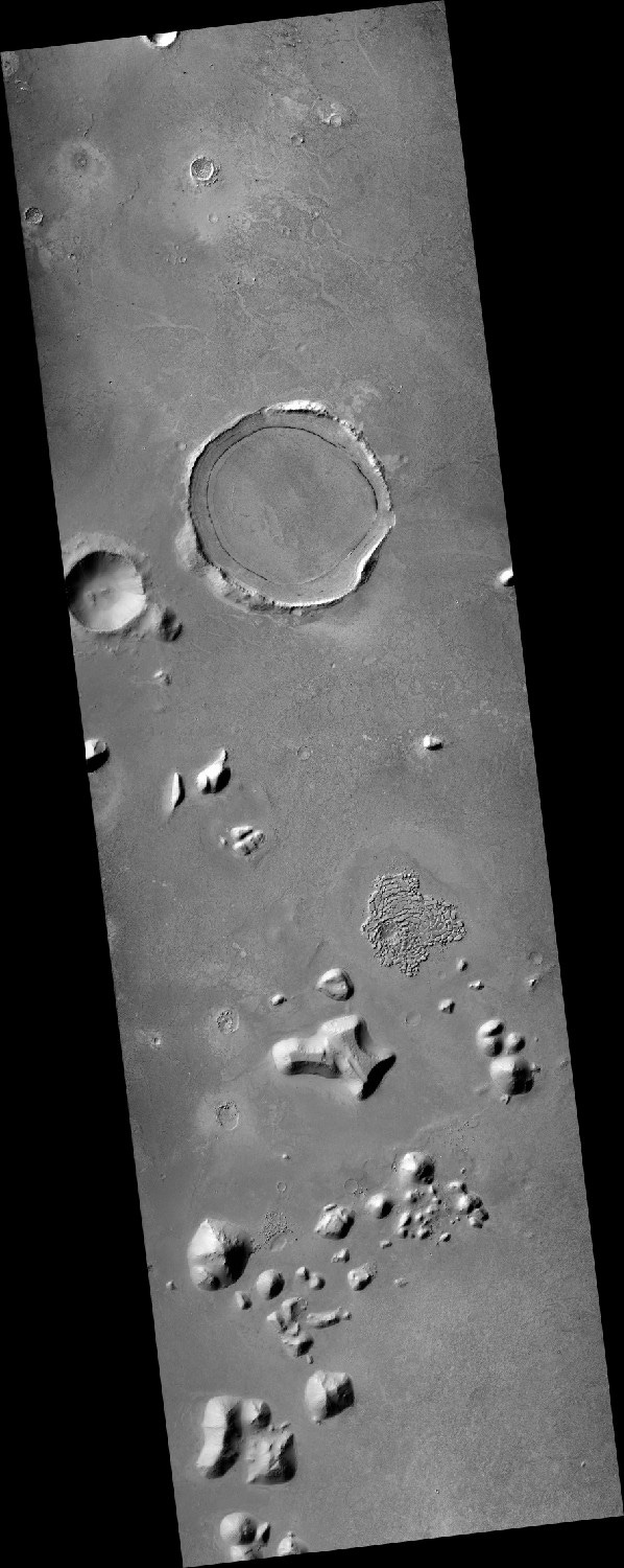
The photo in question is from NASA’s Mars Reconnaissance Orbiter (MRO), a technological marvel which “carries six instruments, three engineering instruments, and two more science-facility experiments”. These features work in tandem to provide scientists with a multilayered view of Martian data. The photo examined in this essay was taken by the Context Camera in June 2008, covering an area of roughly 101 km (62 miles), comparable to the distance between Los Angeles and San Bernadino.
Aerial surveys would only be the first step in exploring potential ruins on Earth. The next step would be on-the-ground field survey where archaeologists can take measurements, gather samples for lab analysis, and dig trenches; that’s where the majority of the work is done. We can’t confirm artificiality from an aerial survey alone, but this is one way to identify areas important enough for further investigation.
Monumental Structures
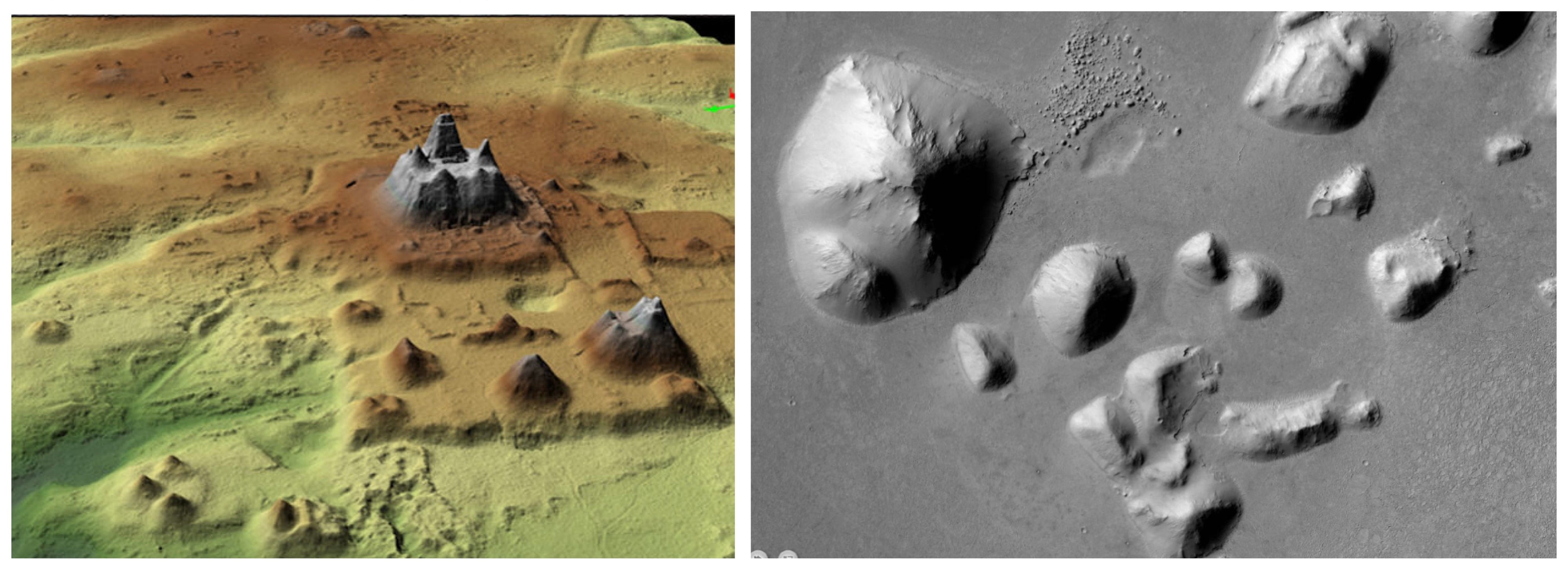
Nearly every structure in this photo has anomalous features. The geometry of the area doesn’t resemble any mountain ranges on Earth or Mars. Earth’s mountain ranges are largely the result of tectonic plates smashing into one another, but Mars doesn’t have tectonic plates. Scientists aren’t sure yet how non-volcanic Martian mountains are even made, but the working theory is that they aren’t so much tectonic “mountains” as masses of sedimentary stone that have been eroded by wind and climate change into shapes resembling mountain ranges. (A lack of plate tectonics also contributes to the survival of surface material.)


Erosion, seismic, and volcanic events do not create the kind of precision seen in the structures in the photo, let alone on so many individual structures in a single area. The landscape includes many smaller anomalous features, some with signs of artistic flourish. There are mounds topped with monoliths. Some of the structures have apparent square-block ruins and boundary walls in their shadows, smaller features that would go unnoticed without careful search.
By following lines of erosion and shadows/highlights, we can see the signs of geometry on the structures beneath. Nature can, of course, generate geometric shapes. But the larger they become, the more the shape is changed by the environment, erasing the “perfection” of the shape. This is part of the reason archaeologists identify potential ruins by looking for large-scale geometry and symmetry.
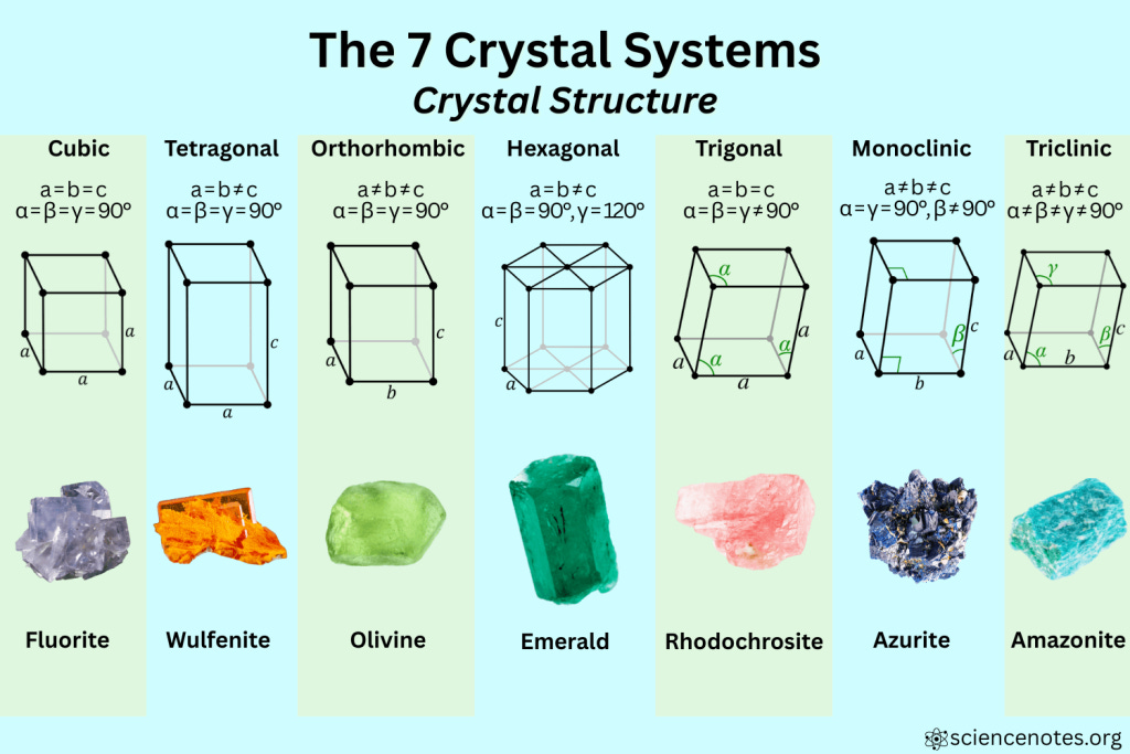
The geometric shapes we see in crystals and minerals is determined at the atomic level. This atomic lattice, essentially a blueprint, builds upon itself in layers. Geometric shapes in the lattice include triangles, cubes, and hexagons. Crystals and minerals grow unevenly and meld with other minerals under the planet’s heat and pressure. Any rockhounder will tell you that identifying a rock with full certainty usually requires examination in a professional lab; that’s how lost the geometric blueprint can become as minerals grow and combine with others. And that’s before shape loss through the chaos of erosion once the minerals are exposed to the surface.
This is all to say that the odds are very much against the natural creation of so many enormous geometric structures. Nature’s geometry may be the very blueprint of matter, but this isn’t how it appears at a macro scale.
Below I’ve collected some of the most impressive geometry in the photo.


There are many structures in this photo with far more precise geometry than ruins on Earth have maintained. But we’re told there could never have been civilization on Mars, therefore this geometry must be natural. We are working backwards from a conclusion.
Craters and Calderas
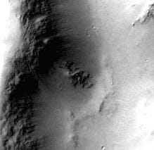
The largest crater in the area is roughly 13 km from top to bottom. It’s likely a volcanic caldera rather than a meteor strike. There are many calderas on Earth filled with water, and this could have been a source of local water if it was ever likewise filled. The caldera is natural but there are some anomalous features around its edges worth examining.
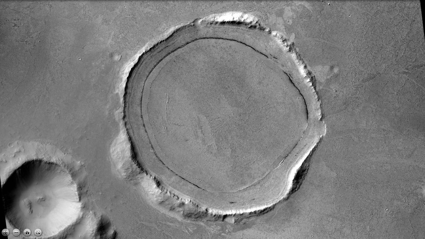
First, there is a highly symmetrical gap in the middle of the right ridge. Judging by the highlights/shadows, it leads down into the caldera. This is a unique formation which opens access to the caldera’s lower ridges. It’s highly unlikely that flowing water alone would create such a symmetrical erosion pattern over such a large area. Also notice the cleared-out ground texture outside the caldera that maintains the exact width of the gap for quite a long distance before blending into the more textured landscape.


Compare the anomalous opening with a naturally eroded section of the caldera’s top ridge. It lacks uniformity or symmetry; we can see where the eroded debris has fallen down the caldera; the edges are softer and more gradual. My interpretation of the photo on the right is natural erosion from a liquid source emptying into the caldera.
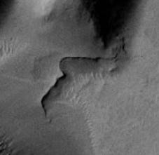
On the near side of the caldera is one of the most fascinating features in the whole photo: an almost perfect, gently graded half-circle carved out of the bottom half of the caldera wall.


There is no pile of debris at the base of the half-circle. Where did all that dirt go? How did a natural process erode such a perfect shape and sloping angle without leaving any debris on the slope itself? Why does the ground texture change sharply at the bottom of the carve-out rather than showing spill-out of eroded material? How did this huge section of erosion happen without the top ridge or walls of the caldera collapsing?
The carve-out is attached to a long “ramp” feature that runs along the side of the caldera and gradually rises in elevation until it reaches the edge of the top ridge. There are mounds atop this ramp feature that maintain the same width for a long distance, a type of uniformity that rarely happens in nature.
There is a section of one mound that appears to be broken off from the rest of the feature, making a sharp, sudden change in direction without losing its shape. It didn’t collapse like a pile of dirt and disappear. There’s nothing gradual about the change. The section coming down the hillside abruptly changes angles without losing its shape. I can only compare the way it looks to a section of piping, or perhaps a railing (neither of which are speculation on its actual function). It doesn’t continue once it reaches the ground but bluntly ends at the point of contact. Regardless of function, its features are highly suggestive of artificial construction.
The adjacent crater is a great example of how ejecta and rebound ridges from a meteor strike typically look. It’s approximately 6 km in size, a terrifying meteor capable of destroying a minimum of ~50km in the immediate area. Without knowing factors like approach angle, speed, mass, and makeup of the asteroid, it’s difficult to know exactly how much destruction this caused when it hit, but safe to say it was locally devastating.


The two craters (or perhaps mounds) below are interesting but difficult to interpret. They’re quite a distance apart from each other, and don’t have the features of a meteor strike. There is at least one symmetrical opening along the outer ridges. The texture inside the craters doesn’t match any texture in the rest of the landscape, nor does it match impact breccia uplifts that appear in complex craters. I certainly have a lot of questions about their unique features, but at this point I’m on the fence about how they were created or why their features are so different.


Mounds and Monoliths
There are a significant number of mounds and monolithic features across the area. Many have geometric shapes, symmetrical openings, and are grouped with other features. At this point it’s impossible to say which of the mounds were purposefully created to be mounds and which were perhaps above-ground structures inadvertently buried by flooding or other natural disaster. However, I assert all of the listed features below were artificially created.


Unique Features
Without a careful search, some of the most intriguing features of this area would go unnoticed. They would not actually be small were we standing in front of them, but compared to the massive structures, they basically disappear into the landscape. They add very important compounding evidence for artificiality.
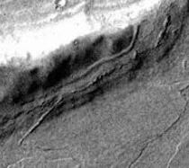
One of my favorite features is “The Wall”. When I first spotted it, I thought it was a photographic error or a left-behind remnant of “stitching” satellite photos together (a normal occurrence in the development process). To verify, I searched for different photos of the area that overlap with the features in this photo. The Wall is still there. It’s not an error; it’s a physical feature on the surface.


I call it a wall not just because of appearance, but its archaeological context. It’s stretched between two large structures at the outermost point where the structures meet the wild. If we accept these structures as artificial buildings, this is exactly the location where a boundary wall would be built. The darker wall stands out starkly against the lighter erosion material, clearly made of different material. We can see from the albedo (reflection) that erosion material is piling up against the inner wall but hasn’t yet piled so high as to cover it. On the outer edge, material blown up against the outside of the wall is darkened by the sharp overhanging shadows of the wall itself. The visible parts of the wall more or less maintain uniform width for roughly 660 meters. There are no other features in the landscape that resemble it.


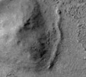
In the bottom left corner of the photo is another highly geometric complex of large structures. Hiding in the deep shadows between the structures is a suspicious pile of rubble in a sunken circular feature that seems to be made of square masonry blocks. The circular feature is also lined so cleanly with a mound feature that it may be another buried wall.


Rock Groupings and Dried Lake Bed
This isn’t a very rocky landscape. What exposed rocks do exist seem to be gathered in specific areas, many near structures, mounds, or circular ground depressions. Rocks rarely wind up in such tight groups through natural means. Take a look at any shoreline or riverbank to see the chaotic dispersion of rocks when moved by water— and we know this area has flooded in the past. This suggests the rocks in the photo could be the localized ruins of artificial structures for which the rocks were purposefully gathered.


The feature below, roughly 7 km from top to bottom, most resembles the cracked mud of a dried-up body of water. If accurate, a settlement located around it makes perfect sense. Chemical analysis would reveal whether it was fresh or salt water. Dried beds tend to look alike at this distance regardless of the water’s saltiness. I will be doing a deeper dive on the geology of the area in Part Two.


Part One Conclusion
This photo includes many points of evidence for possible civilization:
Past habitability of the area
Located in a river valley similar to Earth’s First Civilizations
Complex of large structures with geometric features
Geometric arrangement of structures
At least one likely body of water nearby
Smaller features indicative of infrastructure
Apparent decorative monoliths and mounds
Individual anomalies on Mars are impressive enough. But I believe it is collective settlement patterns that will ultimately lead us to the truth that Mars once had civilization. Skeptics and debunkers have a lot to explain in this photo— not just each individual feature, but why so many of them are in this relatively small area. They have to explain why the broad contextual signs of a settlement pattern are not accurate, but the result of natural forces.
Proponents of the civilization theory only have to be right once.
I believe in open-source research and my work will always remain free. If you would like to support me as an independent researcher and Ufology archivist, please consider subscribing!
Doing a fine job with this research; I’m following closely. One criticism - some the the crater anomalies you’re finding do not necessarily indicate archeological signals. You’ll find the standard model for “impact” craters does not adequately explain crater morphology all over the solar system. A model that better matches actual observation is electrical discharge cratering.
What this means is that crater “anomalies” are less frequently evidence of technological activity and more frequently an indication that our academic institutions are as guilty of hiding scientific evidence as NASA and 3 letter agencies are, whether that be regarding technological civilizations, the origin of our species, or even the real basis of fundamental physics.
Understanding the electrical discharge context will help researchers avoid getting signals crossed when looking for bio and techno signatures. See the work of:
- Gareth Samuel (see the pattern)
- Andrew Hall (electric geology)
- Wal Thornhil
- Stuart Talbot
- Hannes Alfven
- Kristian Birkeland
- Michael Clarage